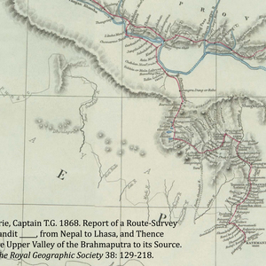
Pundit Map 1868
Dublin Core
Title
Pundit Map 1868
Subject
Environment
Description
A 19th CE map generated by one of the pundits who worked for the British in India. The map shows the pundits route up the Trisuli Valley into Kyirong, over to Tsum, up the Nubri Valley, and into Tibet. Many villages are marked on the route. This is the first known map of Nubri.
Creator
Captain T. G. Montgomerie
Source
Journal of the Royal Geographic Society 1968 38:129 – 218.
Publisher
Journal of the Royal Geographic Society
Date
1/14/2014
Contributor
Geoff Childs
Format
JPEG
Language
English
Type
map
Identifier
Pundit_Map_1868
nub:nubritsum-2014-02-11T18_38_49
Coverage
1868
Citation
Captain T. G. Montgomerie, “Pundit Map 1868,” WUSTL Digital Gateway Image Collections & Exhibitions, accessed July 16, 2024, http://omeka.wustl.edu/omeka/items/show/7704.
Catalog Search
Search for related records in these catalogs:

