< Back
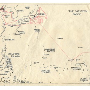
Map drawn by Gass depicting places traveled with U.S. Navy during World War II
Dublin Core
Title
Map drawn by Gass depicting places traveled with U.S. Navy during World War II
Subject
Gass, William H., 1924---United States Navy.
Description
Map drawn by Gass depicting places traveled with U.S. Navy during World War II
Creator
Gass, William H.
Source
Courtesy of William H. Gass
Rights
This item is protected by copyright and/or related rights. For information on procedures and policies governing the use of materials, see http://library.wustl.edu/spec/access/forms/.
Format
Text; 1 jpeg; 300 ppi
Language
English
Type
Maps
Identifier
MSS051_V_western_pacific_world_war_II_map_01_loan.jpg
Files
Citation
Gass, William H., “Map drawn by Gass depicting places traveled with U.S. Navy during World War II,” WUSTL Digital Gateway Image Collections & Exhibitions, accessed July 16, 2024, http://omeka.wustl.edu/omeka/items/show/3414.
Catalog Search
Search for related records in these catalogs:
