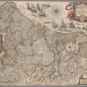
The map of the Netherlands from the fourth volume of Joan Blaeu's Atlas Maior.
Dublin Core
Title
The map of the Netherlands from the fourth volume of Joan Blaeu's Atlas Maior.
Description
The map of the Netherlands that you see here was cut (prior to our care) from the fourth volume of Joan Blaeu's Atlas Maior completed in 1642. The copper plate used to make this impression was that of his father's and dates from 26 March 1608. This is the oldest object held by the Archives of Washington University in St. Louis.
From the Dietrich Gerhard Collection, University Archives, Department of Special Collections, Washington University Libraries.
NOVUS XVII INFERIORIS GERMANIAE PROVINCIARUM TYPUS de integro multis in locis emendatus a Guliel. Blaeu. [The Seventeen Provinces of the Netherlands]. Amsterdam: Printed by the house of Blaeu in 1642 for inclusion in the fourth volume of Joan Blaeu's Atlas Maior and printed from the original copper plate made by Willem Blaeu, dated 26 March 1608.
Identifier
familyblaeu-map-lowres-05.jpg
Files
Collection
Citation
“The map of the Netherlands from the fourth volume of Joan Blaeu's Atlas Maior.
,” WUSTL Digital Gateway Image Collections & Exhibitions, accessed July 6, 2024, http://omeka.wustl.edu/omeka/items/show/8106.
